Hiking, Snow Shoe, and XC Ski Trails
Located just south of Lake Geneva off of South Lakeshore Drive. BFBSP offers many different trails of different lengths. The longest trail is the big loop that is just less than 6 miles. The hike is nice and takes you along the woods and open meadows. It is not a very strenuous of trail so ideal if you are just looking for a nice easy hike or hiking with the family. After the hike the park has many places for a nice picnic or you can go cool down by dipping into the lake. For more information click HERE or contact them at 262-248-2528
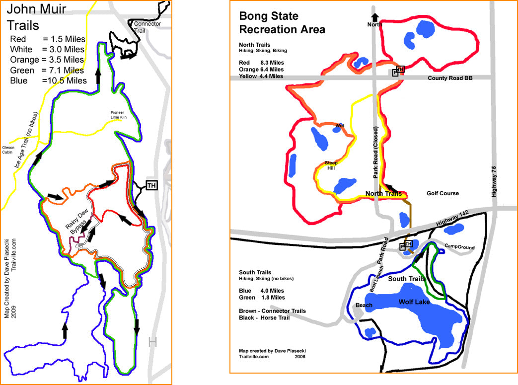
John Muir Trail System
On County Highway H north of the Town of La Grange and US Highway 12 and south of the Town of Palmyra, this is the most popular trail system within hundreds of miles. The John Muir Bike Trails are single-track, mountain bike, hiking, and snow shoe trails that are rough, natural surface trails. Five different loops ranging from 1.25 miles to 12 miles. Parking, water and vault toilets are available.John Muir - Southern Unit, Kettle Moraine State Park. dnr.wi.gov/topic/parks/name/kms/trails.html
Ice Age National Scenic Trail
Explore the 30 miles of Ice Age Trail that goes from the southernmost end to the northernmost point of the Kettle Moraine State Forest-Southern Unit. It's part of the Ice Age National Scenic Trail that eventually will go 1000 miles through some of Wisconsin's most scenic areas. dnr.wi.gov/topic/parks/name/kms/trails.html
Richard Bong State Recreation Area
Bong is a combination of prairie and wetlands with scattered small wooded areas. The terrain is generally flat with some gentle rolling hills and a couple of sections with small but steep hills. The area has trails for hiking, cross country skiing (not groomed), biking, horseback riding, and ATVs. There's also WolfLake (more of a large pond than a lake) where you can launch a canoe or kayak. The trails surface is primarily mowed grass with some dirt/mud areas. May through early June is the absolute best times to walk the trails at Bong since the prairie seems to be exploding with life during this time. Later in the summer as the area dries out things start to turn a bit brown. For more info click HERE
MCMILLER TRAIL SYSTEM
This trail system, on County Highway NN south of the Village of Eagle, provides skiing for skate and classical stride skiers. The trails traverse some significant terrain which provide great training opportunities for all skiers. The trails pass through primarily hardwoods forest and pine plantations. Five trails of different distances and degrees of difficulty greet skiers of all abilities. McMiller's heated shelter building is open every day. The trails are open every day of the week. Hiking is not allowed when the trails are groomed for skiing. McMiller Trail map [PDF].
McMiller also offers a biathlon course for those who participate in this unique sport that combines physically demanding cross-country skiing with rifle marksmanship. The biathlon range at McMiller is open for use from during daylight hours seven days a week. dnr.wi.gov/topic/parks/name/kms/trails.htmlNORDIC TRAIL SYSTEM
This trail, on County Highway H south of the Village of Palmyra, provides hiking and skiing for skate and classical stride cross-country skiers through a variety of vegetation, hardwoods, pine plantations, open meadows and kettle moraine terrain. There are six different trails of varying lengths and degrees of difficulty, providing great hiking or skiing for all levels of ability. A warming shelter is open every day and convenient parking, vault toilets and a sledding hill are also available at the trailhead. Hiking is not allowed when the trails are groomed for skiing. Bikes are not allowed on this trail system. Nordic Trail map [PDF].
dnr.wi.gov/topic/parks/name/kms/trails.html
SCUPPERNONG TRAIL SYSTEM
These trails, on County Highway ZZ just east of Highway 67 north of the Village of Eagle, are open to hikers and classical stride skiers only; skate skiing is not permitted. There are three color-coated loop trails ranging from just over 2 miles to 5 miles. The Scuppernong area provides convenient parking, water and a vault toilet. The trails have a nice rolling characteristic through hardwood forest and pine plantations. Hiking is not allowed when the trails are groomed for skiing. Bikes are not allowed on this trail system. Scuppernong Trail map [PDF].
dnr.wi.gov/topic/parks/name/kms/trails.html
KAME TERRACE TRAIL
An easy 2-mile trail beginning at the Homestead Hollow parking lot by. Open to hikers in the summer and skiers during winter. This trail is located in Lapham Peak Park, Delafield WI. dnr.wi.gov/topic/parks/name/lapham/trails.html
KETTLE VIEW TRAIL
An intermediate 5.8-mile trail beginning at the Evergreen Grove parking lot by the park entrance. Open to hikers in the summer and skiers during winter. Lapham Peak Park, Delafield WI. dnr.wi.gov/topic/parks/name/lapham/trails.html
MAN-MADE SNOW TRAIL
Starting at the park entrance at the evergreen grove parking lot, this 1-mile trail is open to hikers in the summer and skiers during winter. Lapham Peak Park, Delafield WI. dnr.wi.gov/topic/parks/name/lapham/trails.html
MEADOW TRAIL
An easy 2-mile trail beginning at the Evergreen Grove parking lot by the park entrance. Open to hikers in the summer and skiers during winter. Lapham Peak, Delafield WI. dnr.wi.gov/topic/parks/name/lapham/trails.html
MORAINE RIDGE TRAIL
The 7-mile Moraine Ridge Trail is a more advanced ski trail winding through the glacial topography of the forest. The trail starts at the park entrance at the evergreen grove parking lot. Open to hikers in the summer and skiers during winter. Lapham Peak, Delafied WI. http://dnr.wi.gov/topic/parks/name/lapham/trails.html
PLANTATION PATH TRAIL
This 1.8-mile paved trail is accessible to people with disabilities. The trail begins at the Homestead Hollow area and is an interpretive trail through a prairie and wooded area. Lapham Peak, Delafield WI. dnr.wi.gov/topic/parks/name/lapham/trails.html
PRAIRIE TRAIL
The prairie path trail is 4.8 miles loop. There are also several short connecting trails for those that do not want a shorter trip. The trail is open to horseback riders and off-road bicyclists and in winter, snowshoers and hikers. Lapham Peak, Delafield WI.
dnr.wi.gov/topic/parks/name/lapham/trails.html
This trail will be used for Clear Water Outdoor Delafield locations weekly dguided snowshoe hikes. Call our Delafield location to reserve your spot and for shoe rental. (262) 303-4206.